El Niño, a cyclical warming pattern in the Pacific Ocean, enters a new phase this year, and climate scientists warn it will push global temperatures to record highs. The phenomenon occurs when warm water spreads eastward from the western Pacific, disrupting normal trade winds and atmospheric circulation patterns across the tropics.
The World Meteorological Organization confirmed El Niño conditions in June, marking the start of what could be the warmest period on record. When El Niño combines with baseline global warming from greenhouse gas emissions, the compounding effect amplifies temperature increases worldwide. Atmospheric CO2 levels remain elevated, meaning the planet starts from a warmer baseline than during previous El Niño cycles.
Scientists project 2024 could surpass 2023 as the hottest year on record. During the last major El Niño event in 2015-2016, global temperatures spiked dramatically, causing widespread drought, coral bleaching, and agricultural stress across multiple continents. This time, the warming begins from an already elevated temperature plateau, creating additional concern among climate researchers.
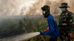
El Niño typically lasts 12 to 18 months. Its effects ripple globally, triggering droughts in some regions while causing flooding in others. Australia, Southeast Asia, and parts of Africa face heightened drought risk. The Atlantic hurricane season may also be suppressed due to increased wind shear.
The convergence of El Niño and ongoing climate change means societies must prepare for heat-related health impacts, water scarcity, and crop failures. Vulnerable populations in developing nations face the greatest risk. Climate scientists emphasize that El Niño is temporary, but the underlying warming trend from human emissions persists regardless of ocean cycles.