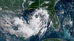
Tropical Storm Bertha has shifted toward the US Gulf coast, bringing dangerous storm surge and heavy rainfall to Louisiana and Mississippi. The National Weather Service warns that storm surges could reach 4 feet along vulnerable coastal sections, posing a serious flooding risk to low-lying communities and infrastructure.
The storm arrives as the Atlantic hurricane season enters its peak months. Forecasters track Bertha's path closely as it approaches landfall, with wind speeds and moisture content determining the severity of impacts. Residents in the affected parishes have received evacuation orders in some areas, while emergency management officials activate response protocols.
Louisiana's coast remains particularly exposed. The state's coastal erosion and subsidence amplify storm surge effects, turning even moderate surges into substantial inundation events. Mississippi's barrier islands and coastal wetlands face similar vulnerabilities. Both states have deployed resources to monitor water levels and prepare rescue operations.
Heavy rainfall accompanying Bertha threatens inland flooding across the region. Tropical systems often stall or slow as they move northward, dumping torrential rain over multiple days. Rivers and bayous already dealing with seasonal water levels could overflow, affecting agriculture, commerce, and residential areas.
This season's tropical activity reflects broader climate patterns. Warmer ocean temperatures fuel storm intensification, while atmospheric conditions determine forward motion and eventual dissipation. Bertha represents the ongoing threat that coastal residents face annually during hurricane season, demanding sustained preparedness and infrastructure investment to protect lives and property.