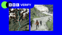
A catastrophic flash flood swept through the Nepal-Tibet border region, carving a deadly path of destruction captured in verified video evidence now traced by BBC Verify.
The flood occurred in the Bhote Kosi River valley, which straddles the Nepal-Tibet frontier. The torrent descended with brutal speed, demolishing settlements, bridges, and infrastructure along its trajectory. Verified footage shows the wall of water moving with terrifying force through narrow gorges, carrying massive boulders and debris downstream. The scale of destruction suggests the flood generated enormous kinetic energy as it raced downhill through the mountainous terrain.
BBC Verify's analysis mapped the flood's progression using multiple verified video sources, geolocation data, and eyewitness accounts. The methodology traced the timing and path of destruction as the waters moved from higher elevations toward lower valleys. Researchers identified key geographic chokepoints where the flood's intensity amplified. The narrow Bhote Kosi gorge channeled the water into a compressed, accelerating mass that gained destructive power with each kilometer traveled.
Flash floods in high-altitude border regions present unique hazards. The Bhote Kosi sits at elevations where sudden weather events, glacier melt, or landslides can trigger rapid water release. The river's steep gradient amplifies flow velocity. When water moves at such speeds through confined valleys, it acquires the force to obliterate concrete structures and relocate massive stones. Settlements built in the floodplain face existential risk during such events.
The human toll extends beyond the immediate flood zone. Communities downstream from the initial surge faced secondary impacts as debris-laden water continued its destructive march. Bridge collapses isolated villages and hampered rescue operations. The flood severed supply lines and communication networks, complicating disaster response efforts. Border locations add complexity to relief operations, as coordination between Nepali and Chinese authorities becomes essential.
This event reflects broader climate and geological patterns in the Himalayan region. Glacial retreat, changing precipitation patterns, and unstable mountainous terrain create conditions for extreme flood events. The Nepal-Tibet corridor remains one of the world's most hazard-prone areas, combining high altitude, steep topography, and seasonal weather volatility.
The BBC Verify investigation provides a critical documentation method for understanding natural disasters in remote regions. Verified video evidence creates a permanent record of the flood's path and intensity. Such documentation serves multiple purposes: it aids disaster response analysis, informs future early-warning protocols, and preserves evidence of how extreme events reshape landscapes.
The flood underscores why communities in high-altitude border zones require enhanced early-warning systems, evacuation protocols, and international cooperation frameworks. As climate patterns shift, the frequency and intensity of such events may increase, making preparedness and rapid response systems more vital than ever in these vulnerable regions.