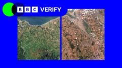
Satellite imagery reveals severe vegetation stress across the UK landscape, with heatwaves and drought creating visible damage to plant life in multiple regions. BBC Verify's analysis tracked these changes using Earth observation data, documenting how prolonged heat and water scarcity have degraded vegetation health over recent months.
The stressed vegetation patterns threaten both wildlife habitats and agricultural productivity. Farms face reduced crop yields and pasture quality, while ecosystems dependent on healthy plant cover lose food sources and shelter. Moorlands, grasslands, and woodland areas show the most pronounced stress signatures in the satellite data.
The UK's recent climate extremes have intensified vegetation strain. Extended periods without adequate rainfall, combined with record temperatures, push plant systems beyond their resilience thresholds. This compounds existing environmental pressures and raises questions about long-term land management and climate adaptation strategies.
Agricultural sectors already grapple with rising input costs and supply chain disruptions. Drought-induced crop failures and livestock feed shortages add pressure to farmers operating on tight margins. Insurance claims and emergency relief measures may follow if conditions persist.
The satellite analysis provides quantified evidence of climate impacts that ground-level observations alone might miss. Tracking vegetation stress through Earth observation enables faster response to emerging agricultural and ecological crises. This data becomes increasingly valuable as extreme weather events become more frequent and severe.
Wildlife management authorities face decisions about habitat restoration and species protection. Conservation efforts may require accelerated timelines and expanded resources to counteract drought-driven habitat degradation.