El Niño has officially begun, according to US scientists at the National Oceanic and Atmospheric Administration, triggering warnings about impending weather extremes and accelerated global warming. The climate pattern, which occurs when warm water spreads across the central and eastern Pacific Ocean, typically disrupts weather systems worldwide.
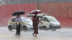
The onset arrives as global temperatures already sit near record highs. El Niño amplifies heat retention in the atmosphere, historically leading to the warmest years on record. Scientists anticipate intensified drought conditions in some regions, flooding in others, and disrupted monsoon patterns across Asia, Africa, and Latin America.
Previous El Niño events have caused severe economic damage. The 1997-1998 event triggered droughts in Indonesia and India, wildfires across Southeast Asia, and widespread crop failures. Coral bleaching accelerated during that period, killing vast reef ecosystems. Current projections suggest similar or worse impacts given already elevated baseline temperatures from climate change.
The timing compounds concerns. El Niño typically persists 9 to 12 months, potentially lasting through early 2024. Combined with human-induced climate change, scientists warn the compound effect could push vulnerable regions toward humanitarian crises. Agricultural yields face pressure in major food-producing areas. Tropical storm intensity may increase, with implications for hurricane seasons in the Atlantic and Pacific.
Weather services worldwide have begun issuing preparedness alerts. Insurance and agricultural sectors are adjusting risk assessments. The event underscores how natural climate variability and anthropogenic warming interact to create compounding hazards. Communities dependent on predictable rainfall patterns face acute vulnerability as El Niño disrupts seasonal expectations developed over centuries.