Hurricanes and typhoons form over warm ocean waters when atmospheric conditions align. The storms develop when sea-surface temperatures reach at least 26.5 degrees Celsius, allowing moisture to evaporate and fuel convection. Low wind shear, atmospheric instability, and sufficient Coriolis force create the rotational structure that transforms tropical depressions into major cyclones.
The naming convention differs by region. The Atlantic and Northeast Pacific use "hurricane," while the Northwest Pacific calls them "typhoons." The Indian Ocean and South Pacific employ "cyclone." The mechanics remain identical across all basins.
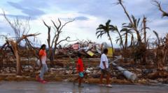
Climate change intensifies these storms through multiple mechanisms. Warmer oceans provide more energy for development, allowing storms to reach higher wind speeds and persist longer over cooler waters. Rising sea levels amplify storm surge damage when hurricanes make landfall. Atmospheric moisture increases in a warming world, meaning more precipitation and flooding.
Scientific data confirms the trend. Research shows that the proportion of Category 4 and 5 hurricanes has increased over recent decades. Storm intensification rates have accelerated, with some systems rapidly strengthening before landfall. While the total number of tropical cyclones may not increase significantly, the ones that form pack greater destructive potential.
The 2023 and 2024 Atlantic hurricane seasons delivered evidence. Hurricane Otis underwent extreme rapid intensification near Mexico, jumping from tropical storm to Category 5 in roughly 24 hours. Multiple storms reached major hurricane status in both seasons, consistent with warming-driven intensification patterns.
Hurricane preparedness becomes more critical as storms grow stronger. Coastal communities face elevated risks from wind damage, storm surge, and inland flooding. Infrastructure designed for historical storm intensity levels requires upgrades to handle the new climate reality.